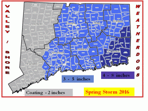
**** First Call Snow Map *****
We say First Call because god only knows this storm will bite us in the butt and make us look like fools. But as of now this is what we are seeing. Could it be less?? Yes… could it be more?? highly unlikely. These totals are on the slightly higher side due to the complexity of this storm.
Timing is still a tough call but most of us will be asleep when the heaviest if you want to call it that of the snow will fall. It looks to last into the morning hours in the West and Central parts of the state. It holds out a bit longer in the East.
School delays will be expected especially in Central and Eastern CT. There may be some delays in the West towns but only as a precaution. Look for cancellations in Eastern CT and maybe some over protective school officials in Central CT.
This will be the heavy wet type snow so we could see some power lines and tree branches come down especially in Eastern CT causing some power outages.
Thats all for now we will follow up later on today. Enjoy the Sun while it lasts. It is much cooler outside and the temps will drop as the day goes along.
Please follow our weather page on Facebook
Valley Shore Weatherdogs
Tom and Kevin

